
Gowganda West
Gowganda West Project
Size: 70.7 sq km or 7070 hectares
Access: Road, 90 minutes from Kirkland Lake
Contiguous to McFarlane Lake Mining Corp. (TSX: MLM). Juby deposit hosts 1.14 Moz Indicated @ 0.95 g/t Au; 5.06 Moz Inferred @ 0.87 g/t Au.*
The structures hosting the Juby deposits trend onto iMetal’s ground
Also contiguous to Orefinders/Angico Eagle
*Source: McFarlane Lake Mining Corp. news release, 2026-Aug-18. MRE prepared by T. McCracken, P.Geo. (BBA E&C Inc.), effective 2026-Aug-14.
**Proximity to mineralization on an adjacent property does not guarantee the presence of mineralization on the property in question
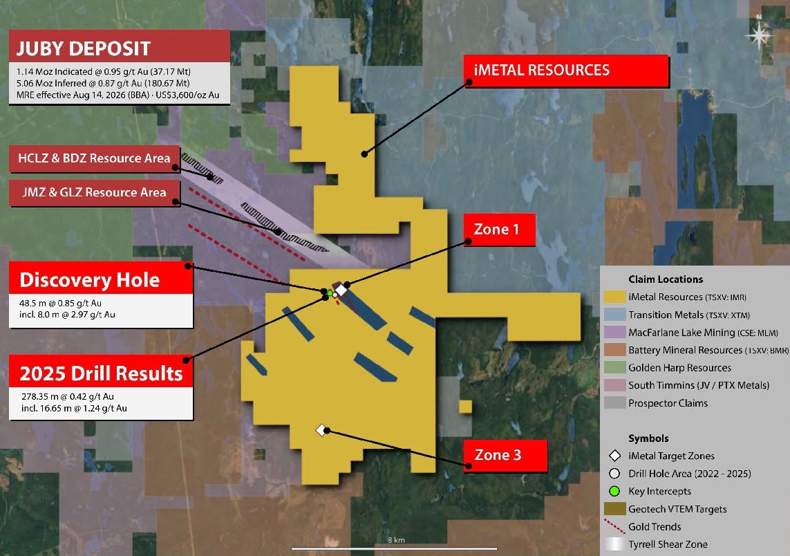
Target Areas
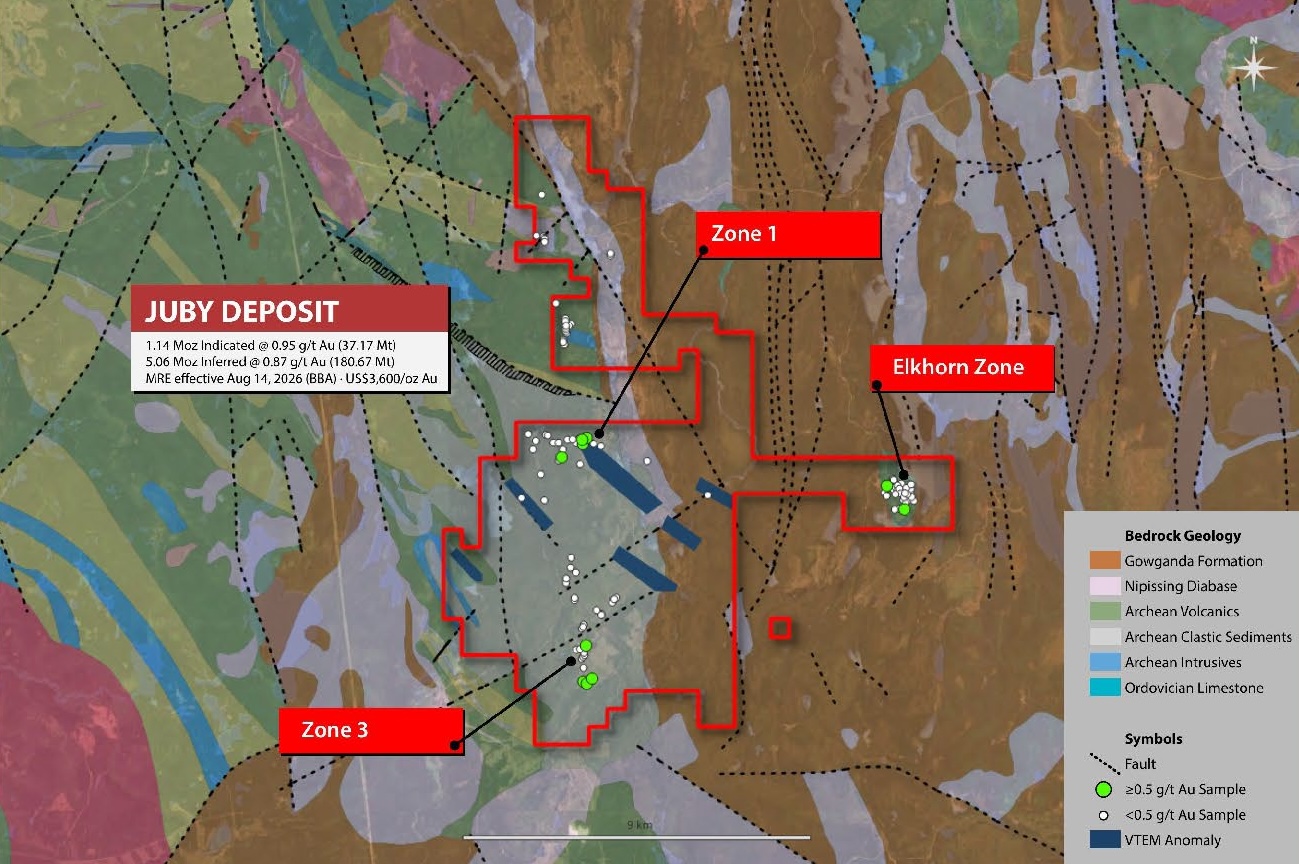
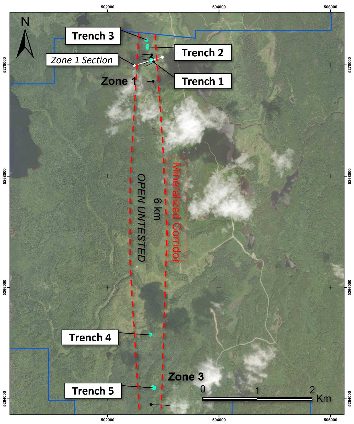
6 km north-south trending corridor of gold mineralization and alteration
Associated with contact between finer and coarser metasediments
Two zones to date within corridor

Zone 1
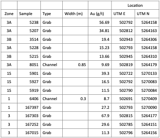
Multiple mineralised trends confirmed by drilling since 2019. 2021 grabs: 27.2 and 16.5 g/t Au.
Zone 3
Alteration and mineralisation increasing toward the southwest. 2021 grabs: 67.9, 29.6 and 11.3 g/t Au.
Elkhorn Zone
Untested VTEM anomaly on the eastern claims — a target for the funded programme.
MLM 826 Zone
Minimally explored structures trending into iMetal’s drilling. JU13-137: 36.3m @ 0.84 g/t Au.
Mineralized Corridor
iMetal’s surface programs have delivered highlight grab samples of 56 g/t Au and channel samples of 23.67 g/t over 0.30 m.
| Location | ||||||
| Zone | Sample | Type | Width (m) | Au (g/t) | UTM E | UTM N |
| 3A | 5238 | Grab | 56.69 | 502792 | 5264158 | |
| 3A | 5207 | Grab | 34.81 | 502812 | 5264163 | |
| 3B | 3514 | Grab | 19.4 | 502943 | 5264306 | |
| 3A | 5228 | Grab | 15.23 | 502793 | 5264158 | |
| 3B | 5215 | Grab | 13.66 | 502945 | 5264310 | |
| 3A | 8051 | Channel | 0.85 | 9.69 | 502819 | 5264179 |
| 1S | 5901 | Grab | 39.3 | 502722 | 5270133 | |
| 1S | 5927 | Grab | 16.5 | 502792 | 5270083 | |
| 1S | 5919 | Grab | 11.5 | 502790 | 5270084 | |
| 1 | 6406 | Channel | 0.3 | 8.7 | 502691 | 5270409 |
| 1 | 167397 | Grab | 27.2 | 502793 | 5270090 | |
| 3 | 167303 | Grab | 67.9 | 502815 | 5264177 | |
| 3 | 167252 | Grab | 29.6 | 502785 | 5264151 | |
| 3 | 167015 | Grab | 11.3 | 502796 | 5264156 | |
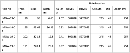
|
Hole Location |
|||||||||
| Hole No | From (m) | To (m) | Width (m) | Au (g/t) | UTM E | UTM N | Azimuth | Dip | Length (m) |
| IMGW-19-04 |
89 |
96 |
6.65 |
1.07 |
502838 |
5270055 |
245 |
45 |
254 |
| IMGW-19-04 |
165 |
195.65 |
30.25 |
0.32 |
502838 |
5270055 |
245 |
45 |
254 |
| IMGW-19-04 |
202 |
221.5 |
19.5 |
0.41 |
502838 |
5270055 |
245 |
45 |
254 |
| IMGW-19-01 |
191 |
220.4 |
29.4 |
0.37 |
502814 |
5270095 |
245 |
45 |
251 |
True widths are not known at this time. No other factors materially affect the accuracy or reliability of the data referred to above. All samples were delivered by the geological contractor to ALS Minerals in Thunder Bay, an ISO/IEC 17025:2017 accredited facility. All samples were analyzed with ALS’s AuME-TL43 procedure, a 25 gram aqua regia digestion with an ICP-MS finish with a 1 gram upper limit for gold. All overlimit gold values were fire assayed with a 30 gram sample and a gravimetric finish, ALS’s Au-GRA21 procedure.
The scientific and technical information contained above has been reviewed and approved by Scott Zelligan, P. Geo (Ontario), VP Exploration of iMetal and a qualified person as defined in National Instrument 43-101.